Discover regular cycling bunch rides near you
For organisers
Your rides,
your community
Whether you run a weekly coffee ride or a full race calendar, Bunchies gives you a free, simple home for your rides. No complicated setup — just add your rides and let the community find you.
Sign in or register to get startedPublic organiser profile
Create a profile for your club, shop, or group with a custom URL. All your rides listed in one place.
Manage your rides
Create a regular or one-off ride listing. Edit details, upload a GPX file, and publish when ready.
Stay confirmed
One click re-confirms your ride as active. Keeps it ranked fresh in search results and removes stale warnings.
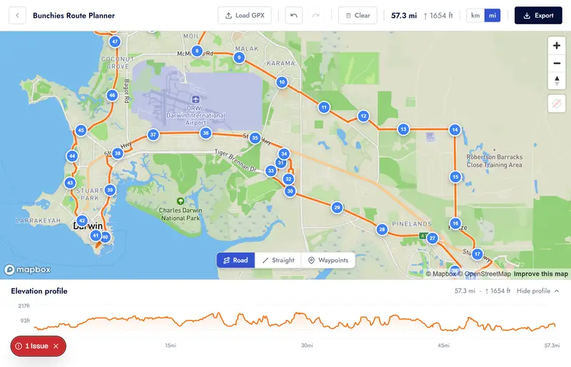
Route Planner
Plan your route, then create a ride.
Completely free!
The built-in route planner lets you build a route on a map — road-snapped or straight-line segments — then export it as a GPX file or instantly convert it into a ride listing with the route preloaded.
- Road-snapped routing via Mapbox Directions
- Straight-line mode for canal crossings and alleyways
- Insert points along any existing segment
- Add named waypoints with descriptions
- Import an existing GPX file to edit
- Export as GPX with terrain elevation data
- Save routes to your profile for easy access when creating rides
- Undo / redo — full edit history
- Elevation profile with gain stats
Community maintained
Data you can actually trust
Bunchies makes it easy for the community to keep things accurate.
Flag inactive rides
Seen a ride that no longer runs? Flag it. Multiple flags automatically surface a warning to other riders.
Suggest corrections
Know the start time changed or the meeting point moved? Submit a change suggestion directly from the ride page.
Ready to find your bunch?
Search for bunch rides near you, or plan your own route and share it with the community.